Deprecated: Required parameter $args follows optional parameter $size in /customers/0/7/2/verdalsportalen.no/httpd.www/wp-content/plugins/basic-user-avatars/init.php on line 251
Warning: Cannot modify header information - headers already sent by (output started at /customers/0/7/2/verdalsportalen.no/httpd.www/wp-content/plugins/basic-user-avatars/init.php:251) in /customers/0/7/2/verdalsportalen.no/httpd.www/wp-content/plugins/leaflet-maps-marker-pro/leaflet-geojson.php on line 49
Warning: Cannot modify header information - headers already sent by (output started at /customers/0/7/2/verdalsportalen.no/httpd.www/wp-content/plugins/basic-user-avatars/init.php:251) in /customers/0/7/2/verdalsportalen.no/httpd.www/wp-content/plugins/leaflet-maps-marker-pro/leaflet-geojson.php on line 281
Warning: Cannot modify header information - headers already sent by (output started at /customers/0/7/2/verdalsportalen.no/httpd.www/wp-content/plugins/basic-user-avatars/init.php:251) in /customers/0/7/2/verdalsportalen.no/httpd.www/wp-content/plugins/leaflet-maps-marker-pro/leaflet-geojson.php on line 282
Warning: Cannot modify header information - headers already sent by (output started at /customers/0/7/2/verdalsportalen.no/httpd.www/wp-content/plugins/basic-user-avatars/init.php:251) in /customers/0/7/2/verdalsportalen.no/httpd.www/wp-content/plugins/leaflet-maps-marker-pro/leaflet-geojson.php on line 283
jsonp({"type":"FeatureCollection",
"features":[
{
"type":"Feature",
"geometry":
{
"type":"Point",
"coordinates":[11.571180,63.636320]
},
"properties":
{
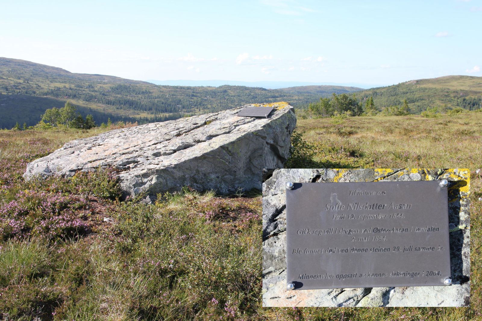
"markerid":"910",
"markername":"Sofiesteinen",
"basemap":"custom_basemap ",
"lat":"63.636320",
"lon":"11.571180",
"icon":"blank_black.png ",
"iconUrl":"http://verdalsportalen.no/wp-content/uploads/leaflet-maps-marker-icons/blank_black.png ",
"address":"",
"text":"
",
"dlink":"http://maps.google.com/maps?daddr=63.636320,11.571180&t=m&layer=1&doflg=ptk&hl=no&om=0",
"zoom":"16",
"openpopup":"0",
"mapwidth":"640",
"mapwidthunit":"px",
"mapheight":"480",
"marker-createdby":"kadillan",
"marker-createdon":"2017-07-30 00:00:00",
"marker-updatedby":"kadillan",
"marker-updatedon":"2017-07-31 00:00:00",
"layerid":["7"],
"layername":"Steiner / varder",
"layer-createdby":"omlarsen",
"layer-createdon":"2017-05-26 00:00:00",
"layer-updatedby":"omlarsen",
"layer-updatedon":"2017-11-09 00:44:02",
"controlbox":"1",
"overlays_custom":"0",
"overlays_custom2":"0",
"overlays_custom3":"0",
"overlays_custom4":"0",
"wms":"0",
"wms2":"0",
"wms3":"0",
"wms4":"0",
"wms5":"0",
"wms6":"0",
"wms7":"0",
"wms8":"0",
"wms9":"0",
"wms10":"0",
"kml_timestamp":"2017-07-30 00:00:00",
"gpx_url":"",
"gpx_panel":"0"
}}]});